Quick Look
Grade Level: 5 (5-7)
Time Required: 1 hours 30 minutes
(can be split into two 45-minute sessions)
Expendable Cost/Group: US $5.00 This activity also uses some non-expendable (reusable) items such as a 3D printer and erosion table; see the Materials List for details and suggestions for alternatives.
Group Size: 1
Activity Dependency: None
Subject Areas: Earth and Space, Science and Technology
NGSS Performance Expectations:

| 3-5-ETS1-1 |
| 3-5-ETS1-2 |
| 3-5-ETS1-3 |
| MS-ETS1-1 |
| MS-ETS1-2 |
Summary
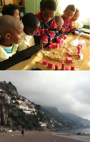
Students learn about water erosion through an experimental process in which small-scale buildings are placed along a simulated riverbank to experience a range of flooding conditions. They learn how soil conditions are important to the stability or failure of civil engineering projects and how a river's turns and bends (curvature, sinuosity) make a difference in the likelihood of erosion. They make model buildings either with a 3D printer or with LEGO® pieces and then see how their designs and riverbank placements are impacted by slow (laminar) and fast (turbulent) water flow over the soil. Students make predictions, observations and conclusions about the stability of their model houses, and develop ideas for how to mitigate damage in civil engineering projects.Engineering Connection
Civil and geotechnical engineers carefully investigate the soil in the surrounding area where structures are going to be built so they can best plan for the future safety of the structures. Civil engineering projects such as skyscrapers, bridges and highways require solid foundations, and preferably placement in areas that are not susceptible to erosion. Engineers must also be knowledgeable of the types of construction materials that can resist water erosion. Engineering solutions to erosion problems may include the extension of foundation systems, installation of vegetation, and modifying the water flow or direction. The erosion table demonstration in this activity shows students how water can move soil and how erosion can affect buildings.
Learning Objectives
After completing this activity, students should be able to:
- Explain the water erosion phenomenon.
- Identify the main causes of erosion along riversides.
- Compare the effects of fast (turbulent) flow versus slow (laminar) flow.
- Identify solutions that engineers design to mitigate water erosion.
Educational Standards
Each TeachEngineering lesson or activity is correlated to one or more K-12 science,
technology, engineering or math (STEM) educational standards.
All 100,000+ K-12 STEM standards covered in TeachEngineering are collected, maintained and packaged by the Achievement Standards Network (ASN),
a project of D2L (www.achievementstandards.org).
In the ASN, standards are hierarchically structured: first by source; e.g., by state; within source by type; e.g., science or mathematics;
within type by subtype, then by grade, etc.
Each TeachEngineering lesson or activity is correlated to one or more K-12 science, technology, engineering or math (STEM) educational standards.
All 100,000+ K-12 STEM standards covered in TeachEngineering are collected, maintained and packaged by the Achievement Standards Network (ASN), a project of D2L (www.achievementstandards.org).
In the ASN, standards are hierarchically structured: first by source; e.g., by state; within source by type; e.g., science or mathematics; within type by subtype, then by grade, etc.
NGSS: Next Generation Science Standards - Science
| NGSS Performance Expectation | ||
|---|---|---|
|
3-5-ETS1-1. Define a simple design problem reflecting a need or a want that includes specified criteria for success and constraints on materials, time, or cost. (Grades 3 - 5) Do you agree with this alignment? |
||
| Click to view other curriculum aligned to this Performance Expectation | ||
| This activity focuses on the following Three Dimensional Learning aspects of NGSS: | ||
| Science & Engineering Practices | Disciplinary Core Ideas | Crosscutting Concepts |
| Define a simple design problem that can be solved through the development of an object, tool, process, or system and includes several criteria for success and constraints on materials, time, or cost. Alignment agreement: | Possible solutions to a problem are limited by available materials and resources (constraints). The success of a designed solution is determined by considering the desired features of a solution (criteria). Different proposals for solutions can be compared on the basis of how well each one meets the specified criteria for success or how well each takes the constraints into account. Alignment agreement: | People's needs and wants change over time, as do their demands for new and improved technologies. Alignment agreement: |
| NGSS Performance Expectation | ||
|---|---|---|
|
3-5-ETS1-2. Generate and compare multiple possible solutions to a problem based on how well each is likely to meet the criteria and constraints of the problem. (Grades 3 - 5) Do you agree with this alignment? |
||
| Click to view other curriculum aligned to this Performance Expectation | ||
| This activity focuses on the following Three Dimensional Learning aspects of NGSS: | ||
| Science & Engineering Practices | Disciplinary Core Ideas | Crosscutting Concepts |
| Generate and compare multiple solutions to a problem based on how well they meet the criteria and constraints of the design problem. Alignment agreement: | Research on a problem should be carried out before beginning to design a solution. Testing a solution involves investigating how well it performs under a range of likely conditions. Alignment agreement: At whatever stage, communicating with peers about proposed solutions is an important part of the design process, and shared ideas can lead to improved designs.Alignment agreement: | Engineers improve existing technologies or develop new ones to increase their benefits, to decrease known risks, and to meet societal demands. Alignment agreement: |
| NGSS Performance Expectation | ||
|---|---|---|
|
3-5-ETS1-3. Plan and carry out fair tests in which variables are controlled and failure points are considered to identify aspects of a model or prototype that can be improved. (Grades 3 - 5) Do you agree with this alignment? |
||
| Click to view other curriculum aligned to this Performance Expectation | ||
| This activity focuses on the following Three Dimensional Learning aspects of NGSS: | ||
| Science & Engineering Practices | Disciplinary Core Ideas | Crosscutting Concepts |
| Plan and conduct an investigation collaboratively to produce data to serve as the basis for evidence, using fair tests in which variables are controlled and the number of trials considered. Alignment agreement: | Tests are often designed to identify failure points or difficulties, which suggest the elements of the design that need to be improved. Alignment agreement: Different solutions need to be tested in order to determine which of them best solves the problem, given the criteria and the constraints.Alignment agreement: | |
| NGSS Performance Expectation | ||
|---|---|---|
|
MS-ETS1-1. Define the criteria and constraints of a design problem with sufficient precision to ensure a successful solution, taking into account relevant scientific principles and potential impacts on people and the natural environment that may limit possible solutions. (Grades 6 - 8) Do you agree with this alignment? |
||
| Click to view other curriculum aligned to this Performance Expectation | ||
| This activity focuses on the following Three Dimensional Learning aspects of NGSS: | ||
| Science & Engineering Practices | Disciplinary Core Ideas | Crosscutting Concepts |
| Define a design problem that can be solved through the development of an object, tool, process or system and includes multiple criteria and constraints, including scientific knowledge that may limit possible solutions. Alignment agreement: | The more precisely a design task's criteria and constraints can be defined, the more likely it is that the designed solution will be successful. Specification of constraints includes consideration of scientific principles and other relevant knowledge that is likely to limit possible solutions. Alignment agreement: | All human activity draws on natural resources and has both short and long-term consequences, positive as well as negative, for the health of people and the natural environment. Alignment agreement: The uses of technologies and any limitations on their use are driven by individual or societal needs, desires, and values; by the findings of scientific research; and by differences in such factors as climate, natural resources, and economic conditions.Alignment agreement: |
| NGSS Performance Expectation | ||
|---|---|---|
|
MS-ETS1-2. Evaluate competing design solutions using a systematic process to determine how well they meet the criteria and constraints of the problem. (Grades 6 - 8) Do you agree with this alignment? |
||
| Click to view other curriculum aligned to this Performance Expectation | ||
| This activity focuses on the following Three Dimensional Learning aspects of NGSS: | ||
| Science & Engineering Practices | Disciplinary Core Ideas | Crosscutting Concepts |
| Evaluate competing design solutions based on jointly developed and agreed-upon design criteria. Alignment agreement: | There are systematic processes for evaluating solutions with respect to how well they meet the criteria and constraints of a problem. Alignment agreement: | |
International Technology and Engineering Educators Association - Technology
-
Students will develop an understanding of engineering design.
(Grades
K -
12)
More Details
Do you agree with this alignment?
-
Apply the technology and engineering design process.
(Grades
3 -
5)
More Details
Do you agree with this alignment?
-
Illustrate that there are multiple approaches to design.
(Grades
3 -
5)
More Details
Do you agree with this alignment?
State Standards
New York - Science
-
Define a simple design problem reflecting a need or a want that includes specified criteria for success and constraints on materials, time, or cost.
(Grades
3 -
5)
More Details
Do you agree with this alignment?
-
Generate and compare multiple possible solutions to a problem based on how well each is likely to meet the criteria and constraints of the problem.
(Grades
3 -
5)
More Details
Do you agree with this alignment?
-
Plan and carry out fair tests in which variables are controlled and failure points are considered to identify aspects of a model or prototype that can be improved.
(Grades
3 -
5)
More Details
Do you agree with this alignment?
-
Define the criteria and constraints of a design problem with sufficient precision to ensure a successful solution, taking into account relevant scientific principles and potential impacts on people and the natural environment that may limit possible solutions.
(Grades
6 -
8)
More Details
Do you agree with this alignment?
-
Evaluate competing design solutions using a systematic process to determine how well they meet the criteria and constraints of the problem.
(Grades
6 -
8)
More Details
Do you agree with this alignment?
Materials List
This activity was designed for classrooms with access to a 3D-printer and an erosion table. However, if either tool is unavailable, instructions are provided for alternative materials.
The class needs:
- simulation of river flow, via an erosion table with hydraulic bench OR a stream table OR a homemade erosion table; see below for details on these options
- small-size model buildings, one per student, made via 3D printer (plus computer and free drawing software) OR LEGO pieces; see below for details on these options
- 10 pounds fine sand ($5)
- water, sink and buckets
- Erosion in Rivers Pre-Activity Quiz, one per student
- Erosion in Rivers Post-Activity Quiz, one per student
River Simulation Options 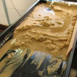
- Erosion table with hydraulic bench for academic purposes, such as the Hydro-Geology Stream table – Hubbard (product #Z06394M) for $1,330 from Nasco at https://www.enasco.com/p/Z06394M; the recommended table dimensions are 26-in wide x 66-in long x 6-in deep; the author performed the activity using this erosion table, shown in Figure 1.
- Alternatively, use a stream table, such as the Stream Table Kit (product #SB01704M) for $80 at Nasco at https://www.enasco.com/p/SB01704M; its heavy plastic tray is 14-in wide x 48-in long x 3-in deep with a drain hole.
- Alternatively, create a homemade erosion table; although a bit more work, it is an efficient low-cost alternative that can be created for ~$41 using the following supplies:
- a large plastic box of similar dimensions to the erosion and stream tables; manually create a drain (hole) on one end; estimated cost $12
- bucket or pan, to collect the water; estimated cost $5
- filter, such as a piece of cheesecloth, to keep soil from escaping the pan; estimated cost $4
- a pump, with velocity or flow meter if possible, so students can observe differences in erosion effects due to flow rate changes; estimated cost $20
Model Buildings Options 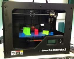
- 3D printer, for example, the many models made by MakerBot Industries such as the MakerBot Replicator 2 (Figure 2; $2,000) or MakerBot Replicator Mini Compact ($1,375) at https://store.makerbot.com/; the author used an earlier version of these 3D printers, the Thing-o-matic by Makerbot (http://www.makerbot.com/support/thingomatic/); using any 3D printer also requires the use of computers and software, such as:
- computer, one per student; alternatively, small groups of up to three students could work together on one computer so fewer computers are needed
- 3D modeling drawing application, for designing building units, such as Google Sketch Up (www.sketchup.com; free) or 3D Tin (www.3dtin.com; free); helpful tips, tutorials and download information are available at http://makezine.com/2013/03/28/free-alternatives-to-tinkercad/
- For design ideas and downloadable designs, use http://www.thingiverse.com/; suggested designs include http://www.thingiverse.com/thing:151430 and http://www.thingiverse.com/thing:150956
- a supply of the filament material the 3D printer uses to make the building models
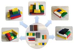
Figure 3. Using the same LEGO pieces, students create their own model buildings.
- Alternatively, give each student an identical set of 20-25 LEGO pieces (estimated cost $3), from which they can make their own unique model buildings (Figure 3); available for purchase at http://shop.lego.com/en-US/Pick-A-Brick-ByTheme;%20http://creative.lego.com/en-us/default.aspx; a suggested mix of typical LEGO pieces for a set of 19 includes the following pieces:
- (2) 2 x 6 (one thickness)
- (2) 4 x 8 (one thickness)
- (2) 2 x 8 (one thickness)
- (4) 2 x 3 (double thickness)
- (1) 2 x 6 (double thickness)
- (4) 1 x 8 (double thickness)
- (4) 2 x 8 (double thickness)
Worksheets and Attachments
Visit [www.teachengineering.org/activities/view/nyu_erosion_activity1] to print or download.Pre-Req Knowledge
The teacher must have a basic knowledge of the water and rock cycles, erosion in rivers and weathering, as well as soils and rocks.
Introduction/Motivation
What is a civil engineer? (Listen to student ideas.) Civil engineers are the people in your community who design projects such as highways, bridges, tunnels, dams, skyscrapers and the many buildings that we rely upon in our communities. They make sure that these projects do what we want them to do and are safe. Some of these civil engineers specialize in certain areas, such as structural, geotechnical, environmental, water and traffic engineers—but they are all considered civil engineers. These engineers play many roles in the design, maintenance and improvement of urban areas. For example, structural engineers design bridges, factories, apartment buildings, retaining walls and other buildings and structures. Water resource engineers design ways to move clean water and waste water around cities and regions by creating dams, reservoirs, treatment plants, piping systems and canals, while environmental engineers make sure that the water is safe for humans and the environment. Transportation engineers plan the systems behind our road, railway, shipping and airplane transport systems. Geotechnical engineers study the mechanical behavior of earth materials, including soil, rock and groundwater.
Soils may seem simple, but in fact they can vary greatly. Engineers analyze the many characteristics and properties of soils. How soils behave is influenced by the physical material that makes up the soil as well as weather and climate. The physical content of soil changes over time, and the soil profile (what is present in the soil) of a specific area of ground can reveal a lot of information about a geographical location. Over time, different events cause soil to change in a variety of ways. For example, if some pollution (contamination) occurred in a particular area and left a residue of some kind, the soil profile would reveal this.
What kinds of soil types can you think of? (Listen to student ideas.) In general, engineers consider four types of soil: clay, silt, sand and gravel/rock. Clay and silt are very small pieces of soil. Sand particles are bigger than clay and silt, and rock is the biggest. Major climatic events can also impact the development and properties of soil—events such as hurricanes, blizzards and droughts can greatly contribute to the properties of soil.
Have you ever heard of the word "erosion" before? (Write "erosion" on the classroom board.) What is erosion? Erosion is the process of wearing away the surface of the Earth in different ways. Erosion can happen in many, many forms (water, waves, wind, glacier, chemical, temperature). One of the most common ways that soil erodes is by water. Have you seen small clods of sand being washed out or moved around by water? This happens because of water erosion. Since erosion moves soils and rocks from one place to another, it continually changes the surface of the Earth. The Grand Canyon was formed due to water erosion over many, many years! This is impressive, because compared to other material that make up the Earth, gravel and rock are the most difficult to erode.
In rivers, the erosion phenomenon also changes the edges of riverbanks, as water energetically acts against the soils. The movement, or flow, of water in rivers is not always the same; the speed of water changes depending on the location in the river. For example, when water goes around a turn in a river, the water on the inside of the turn moves faster than the water on the outside of the river. When water moves fast, it is called turbulent flow; when water moves slowly, it is called laminar flow. So, the path of a river, specifically how many turns it has, can change how the water moves through it, which causes erosion. 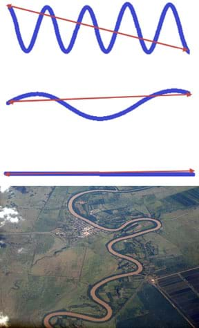
How many turns, and what they look like, in a river, is called curvature. The magnitude, which is the size of the curves, or turns, in a river tells engineers how likely erosion is to occur, or how susceptible the river is to erosion. Engineers use the term sinuosity or sinuosity index to describe the shape of a river; it is defined as the path the river takes compared to the shortest possible path that can be taken. For example, a very curvy river has a higher sinuosity then a straight river. (Draw Figure 4 on the classroom board.) This top graphic describes a river with high sinuosity, the middle one describes a river with a medium sinuosity, and the bottom graphic describes a completely straight river with a sinuosity of 1.
As water travels over the land, it takes some soil with it and leaves or deposits some along the path it takes; this is called deposition. Because water moves some of the soil, through the process of erosion, any buildings or structures on top or nearby that river and its surrounding soil can be affected. In the same way a sand castle on the beach needs a certain amount of wet and dry sand to stand tall and strong, real buildings need a certain blend of soil below them to stand strong, tall and unmoving; this is called stability.
Because of ongoing erosion in the environment and the lack of knowledge by some builders, sometimes a loss of stability occurs, which can lead to the collapse, or failure, of structures. The "failure of structures" is defined in many ways by engineers. In general, failure means that the building does not meet certain standards, or requirements, put in place by a governmental agency. These standards describe allowable movement of structures. Some buildings that are considered to be stable today may be at risk because the erosion taking place in a certain river is threatening their stability. Engineers study erosion so that they can protect the environment, structures, landmarks and people's lives. They design solutions to prevent damage to structures and keep people safe. Civil engineers are responsible for designing buildings that are stable; geotechnical engineers are responsible for making sure the soil underneath buildings is stable.
Soil erosion occurs naturally, but is also the result of land changes caused by people. In fact, soil can be structurally reinforced using a variety of materials and design methods, similar to how concrete is reinforced using steel rebar. Foundation stability of structures is important in order reduce the risk of failure. If engineers do not take erosion into account when designing structures, many failures, or near failures, can occur. Major climatic events can also cause the surface of the Earth to erode, breaking down rocks and depositing sediment in new locations. Unlike common weather events, these major events can affect the surface of the Earth dramatically. Engineers are responsible to ensure that even if a major climatic event occurs, the erosion will not damage the surrounding structures. The changing cycles of natural disasters and hurricanes call for engineers to come up with new, innovative ideas to mitigate the disaster risks. What are some new, innovative ideas that you can come up with to help people prepare for hurricanes or floods?
Procedure
Simulation and Fabrication Tools
An erosion table and hydraulic bench system provide a way to simulate river and/or flood water flowing through an enclosed soil site so that the relationship between water velocity and soil erosion can be easily investigated. A classroom erosion table enables students to visualize the effects that a river or stream can have on surrounding soil, which affects surrounding structures.
Google Sketch Up and 3D Tin are two online applications that can be used for three-dimensional (3D) design for use in 3D printers. These simple programs enable students to imagine and design prototypes of real objects through easy-to-use tools. The web interfaces are very natural and the mix of colors plus the solid building block modeling system makes for a fun way to quickly replicate designs. This aspect of the activity enables each student to express his or her imagination and take ownership of the experiment.
Before the Activity
- From the options presented in the Materials List section, decide what you will use for the river erosion simulation and model buildings. As necessary, briefly research and explore the 3D modeling program options.
- If 3D-printed buildings are being used, set aside a separate time to have students design and print the small-scale buildings so they are ready to use when starting this activity.
- (optional) Prepare introductory lessons about the rock cycle and water cycle to provide context for this activity and help students visualize and participate in the way the cycles work. See some suggested resources in the Additional Multimedia Support section.
- (optional) Assemble a few photographic images to help incite discussions about soil erosion, such as images of collapsed structures due to erosion caused by the river layout. Use search terms such as: soil erosion, river erosion, collapsed structures, riverbank collapse. See some suggested images in the Additional Multimedia Support section.
- Gather materials and make copies of the Erosion in Rivers Pre-Quiz and Erosion in Rivers Post-Quiz, one each per student.
- Prepare the erosion table (or stream table or homemade erosion system) with a variable path. Make the river have some tight curves, some wide curves and some straight paths, in order to expose students to different river scenarios.
With the Students
- Teach students about erosion, including the information provided in the Introduction/Motivation section. Explain new vocabulary terms.
- Challenge students to brainstorm ideas to mitigate disasters caused by erosion. Discuss their predictions and remediation solutions. Record important input by students on the classroom board.
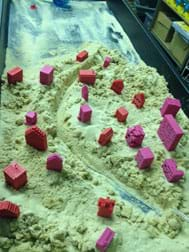
Figure 5. Students place their model buildings along the riversides, at locations where they predict they will be stable and safe from erosion. - Administer the pre-quiz and have students complete them independently.
- Give students their already-made 3D-printed model buildings, or have students design and construct LEGO buildings with sets of LEGO pieces you provide.
- Then move to the erosion table and ask each student to predict where on the riverbank s/he wants to place his/her model building so that it provides a nice river view but is also safe from erosion. The goal is for their structures not to move due to water erosion. Then have students place their buildings along the river (Figure 5).
- Once every student has made a prediction and placed his/her building, open the hydraulic bench pump at a low flow rate to allow water to run under laminar flow (slow, steady, constant). Remind students that laminar flow is slow-moving water. Expect a few buildings to collapse due to soil erosion, while most survive. (Note: For this activity, a building collapse means that it moves a noticeable amount, including falling over, tilting or moving downstream.)
- Once the effects of the laminar flow are established, incrementally increase the flow rate in order to simulate large storms and turbulent flow (fast, rapid, erratic). Remind students that turbulent flow is fast-moving water.
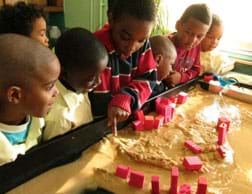
Figure 6. Students observe their buildings' performances during the modeling of turbulent flow. - As the flow rate is increased, make sure students observe the increase in the rate of erosion and encourage them to pay special attention to the locations they selected—areas where they believe no damage will occur. Expect the simulation of heavy storms and turbulent flow to result in the failure of many buildings, as shown in Figure 6.
- Once the results of the erosion due to turbulent flow are clear, lead a class discussion. Refer to the Assessment section for suggested questions and topics.
- Conclude by administering the post-quiz, having students independently complete them.
Vocabulary/Definitions
civil engineer: A person who uses his/her understanding of science and math to design, build and maintain projects such as roads, highways, bridges, canals, dams, tunnels, skyscrapers and other buildings that we rely upon in our communities.
curvature: How many turns a river takes and what size they are.
deposition: The process of leaving small pieces of soil behind after water erodes land.
erosion: The wearing away of the surface of the Earth by natural processes such as wind or moving water.
geology: The scientific study of the Earth, how it is formed, and how it changes over time.
geotechnical engineering: A branch of civil engineering that studies the way Earth behaves (mechanical behavior of earth materials), including soil, rock and underground water (groundwater).
laminar flow: Slow, steady, constant flow of water.
magnitude : The size of something; how big or small something is.
rock: A solid material made of one or more minerals; stone.
sinuosity: A number used to describe the curvature of the path a river takes, compared to the shortest possible path that can be taken.
soil: A natural resource made of broken-down pieces of living and non-living earth materials. Can change form through the rock and water cycles. Three phases of matter occur in soil: solids, water and air. Also called dirt.
stability : The ability of a building to stand strong over time, especially after erosion occurs.
susceptibility: The chance that something will be damaged or harmed.
turbulent flow: Fast, rapid, erratic or chaotic flow of water.
velocity: How far you go in a certain amount of time (distance traveled per time taken); speed.
water erosion: The movement of soil due to moving or flowing water. Also known as valley erosion, stream erosion or gully erosion.
Assessment
Pre-Activity Assessment
Pre-Quiz: Administer the Erosion in Rivers Pre-Quiz. Review students' answers to learn their baseline understanding of erosion. A space is provided for students to draw in their building locations before flooding, which helps them predict where to put their buildings on the erosion table.
Activity Embedded Assessment
Questions: During the activity, while students are considering building placement, ask questions such as:
- Why not place your building in the middle of the river? (Answer: It would collapse inmediately! Also, water bodies are state property, and no construction is permitted to be placed on them.)
- Do you think the design of your building can affect how erosion acts on it? (Answer: Yes! Stable structures resist erosion much better.)
Post-Activity Assessment
Concluding Discussion: After completing the activity, informally assess students through in-class questions to determine the impact of the activity on their learning.
- Ask students to share their observations and describe how their model buildings performed.
- Ask students to relate the performance results to where their buildings were located with respect to the river shape and curvature.
- Ask other questions to elicit whether students understand the concept of erosion in rivers, the need to design and build appropriate structures in the right locations, and the role of civil engineers in ensuring peoples' safety while designing new structures.
- Review the answers to the pre-quiz.
- Ask the Investigating Questions.
Post-Quiz: At activity end, administer the Erosion in Rivers Post- Quiz to assess students' understanding of erosion. Review their answers to gauge their comprehension and get their feedback from the activity.
Investigating Questions
- What is water erosion? (Answer: It is the process by which soil is removed from the Earth due to water impact, and then transported and deposited in other locations downstream.)
- Does the river sinuosity or curvature affect the erosion in the riversides? (Answer: Yes! The more curve of the river, the more loss of soil when water impacts the riverside.)
- How can you avoid building damage due to water erosion? (Example answers: Do not build in areas susceptible to erosion. Prior to construction, completely understand the specific geology of the surrounding area and soils in order to predict any erosion phenomena that might occur; this helps engineers decide exactly where to locate new buildings as well as any design or structural steps to make the building more stable at that location. Choose construction materials that resist water erosion. Provided adequate foundation systems anchored to bedrock. Install vegetation to help the soil resist erosion. Modify the water flow or direction.)
Activity Scaling
- For lower grades, use less technical vocabulary and modify the Introduction/Modification content to present the activity in a simpler fashion. Instead of designing and printing 3D buildings, use LEGO pieces to make this activity more accessible to younger students. Have students work in groups. Have them create a checklist of the steps they need to follow in the activity and a list of what they observe.
- For higher grades, have students do Internet searches for more in-depth information on erosion. Have them draw their predictions of what will happen when water flows down the erosion table. Also have them make predictions for different patterns of river flow.
Additional Multimedia Support
Resources for introductory lessons and activities about the rock cycle and water cycle:
- Rock Cycle curricular unit
- Earth Rocks! lesson
- Ride the Rock Cycle lesson at http://209.7.198.36/geologyonline/lessons/6.4/lesson.pdf
- Fresh or Salty? lesson
- Where Has All the Water Gone? lesson
- Water Cycle Game at http://www.nps.gov/wica/forteachers/upload/Hydrology-Water_Cycle_Game-2.pdf
- U.S. EPA water cycle interactive games and activities at http://water.epa.gov/learn/kids/drinkingwater/gamesandactivies.cfm
Example soil erosion images to show students:
- http://www.cambodiadaily.com/archives/three-missing-after-mekong-riverbank-collapse-in-kandal-52710/
- http://commons.wikimedia.org/wiki/File:River_Erosion_-_geograph.org.uk_-_358650.jpg
- http://assets.knowledge.allianz.com/img/natural_disasters_dangerous_building_eroding_cliffs_landslide_q_49122.jpg
- http://www.vanguardngr.com/2012/06/erosion-anibeze-community-cries-out-for-help/
- http://en.wikipedia.org/wiki/File:River_erosion_near_Arncliffe,_Littondale,_Yorkshire_Dales_-_geograph.org.uk_-_40749.jpg
- http://upload.wikimedia.org/wikipedia/commons/b/b0/Dead_Sea_Coastal_Erosion_March_2012.JPG
- http://www.masterbuilder.co.in/wp-content/uploads/2013/06/212.png
- http://www.epa.gov/climatechange/images/impacts-adaptation/GroundCollapsing.jp
- http://www.nmdirtbags.com/images/coast_highway.jpg
- http://archives.thestar.com.my/archives/2006/11/29/nation/temple.jpg
- Cartoons and comics http://www.cartoonstock.com/directory/e/eroded.asp
Subscribe
Get the inside scoop on all things TeachEngineering such as new site features, curriculum updates, video releases, and more by signing up for our newsletter!More Curriculum Like This

Students are introduced to the primary types of erosion—chemical, water, wind, glacier and temperature. Students investigate examples of each erosion type and discuss how erosion changes the surface of the Earth.

Students learn about geotechnical engineers and their use of physical properties, such as soil density, to determine the ability of various soils to offer support to foundations.

Students learn about landslides, discovering that there are different types of landslides that occur at different speeds — from very slow to very quick. All landslides are the result of gravity, friction and the materials involved. Students learn what makes landslides dangerous and what engineers ar...

Students learn the basics about soil, including its formation through the cycling of the Earth's materials, as well as its characteristics and importance. They are also introduced to soil profiles and how engineers conduct site investigations to learn about soil quality for development, contaminatio...
Copyright
© 2014 by Regents of the University of Colorado; original © 2012 Polytechnic Institute of New York UniversityContributors
Sophia Mercurio, Eduardo SuescunSupporting Program
AMPS GK-12 Program, Polytechnic Institute of New York UniversityAcknowledgements
This activity was developed by the Applying Mechatronics to Promote Science (AMPS) Program funded by National Science Foundation GK-12 grant no. 0741714. However, these contents do not necessarily represent the policies of the National Science Foundation, and you should not assume endorsement by the federal government.
Last modified: March 14, 2023


User Comments & Tips